Wednesday, September 26, 2012

Hammonasset to Madison RR Station

Well if you draw a line across the southern part of this state and divide it by half, this is about the half way point-I don't think that  this straight line relates accurately  to this walk or all the in and outs and that is what  this walk has become?


When I started this leg I was going to do a 2.5 mile in and out, but on the great perfect New England day, we somehow  ended up in downtown Madison (5.8 miles) with hopes of taking that taxi cab back, but that never happened so I walked back and ended up with almost 11 miles: poor Dom and poor knee.
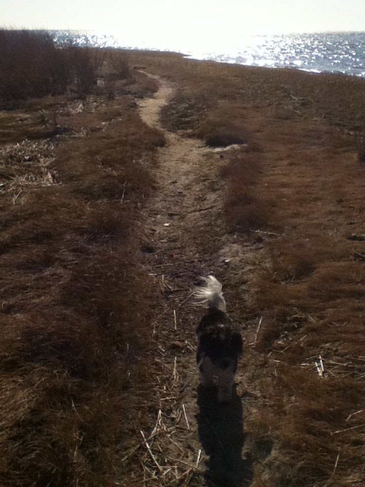
I started at Hammonesset, across the river from where I stopped last time. I have been here only a few times on the few bike bikes here  and I droves as far south as I could, then  parked the car and started on a bluff like out cropping and then headed north on a nice big beach, which is Hammonasset I think a large west facing beach which was nice walking on a a cool morning.
 
I could not figure out the many many conflicting "no dogs" "no pets" signs all over and various degrees of dates, Oct 15 or Oct 31 and there were a lot of "dogs on leash only" signs and there were plenty of dog mitt bag dispensers around, just like every coastal town trying to balance everything.
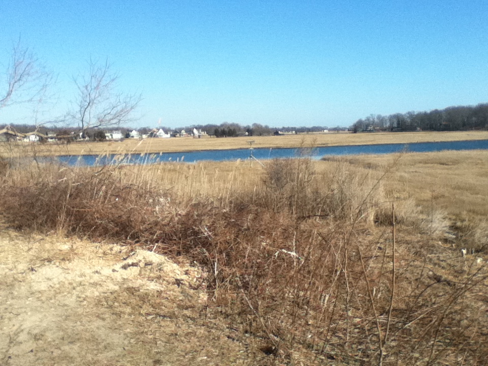
Heading north I cut through a campground and a pair of birders helped me find the new  path that paralleled Rte 1-the Shoreline Greenway. today the gate of the chain link fence was locked so we followed a faint path to the end of said fence. After a short time on busy RTE 1 we headed on another section of the greenway, a lovely little "U" on a low buff in woods overlooking a salt marsh with Long island Sound in the distance with those big billowing clouds. This section was carefully graded and the surface was rock similar to RR beds. A set of stone steps on a small rise provided a nice spot for rest and enjoying the views.


after another short stint on Rte 1 we headed west on Liberty St, a house of older houses and big new ones, all bordered by green and a very nice walk. I decided Agana's walking along the shore roads-roads that kind of go along the sound but decided it be better to stick on Liberty, a new road for me.
 
Ending up in Madison Center, this was also new because I usually take the aforementioned shore route on bike ride. We stopped a bench in the shade and rested and had lunch, a peanut butter and jelly and orange today. I called Linda and she gave me the number for the taxi, which I had thoughts about taking. I had emailed then last winter about taking the dog and had called them on an earlier walk but the delay was too long for me that day. Anyway in Madison I called and got an answering machine....so from the RR station I decided to start walking   back until they called, well it was almost 50 minutes before I got that call and I was 2 miles on my way. so much for that idea.


At this time I was running low on water and I guess I could have stopped by and taken the dog into Cumberland Farms or something, but I wasn't in the mood for that. We had water and I gave Dom frequent water breaks, I think that this was already her longest walk and we were adding to it.


Getting back to the campground I found a nice water faucet and we got to replace , it wasn't a hot day but that doesn't matter to me as far as fluids goes.


I tried to dead reckon my way to the car in a maze of parking lots campgrounds and ponds, thought that I could cut out distance but not really. There is bike path, actually a sand path just in from the beach so we traveled that and by this time, 3 PM the small trees provided a lot of shade for dog.
 
She did good, and  was pretty tired but recovered nicely.
 
My friend Paul gave me a GPS  and I used it on this walk, it was good because there is no way to measure this walk on Gmaps....also in real time it gave me clues as to where to go and road map was useful In Madison  finding roads.
 
This had to be the best walk, the open beaches, the short greenway walk along the salt marsh, Liberty St and downtown Madison, another town that time forgot.

Now, have to start thinking where to go from here?


Friday, August 31, 2012

Clinton Green to end of Pratt Rd ( and return)

Haven't been out here in a while....it was a  45 mile drive today. Didn't realize it was going to be in the 90s today or else I would have started earlier. I decided at the last minute to see how far I could get on side roads and skip the way I had planned-Rte 1 and all its crapiness.

Parked at the Clinton Green which is on a quiet stretch of the Post Road and pretty small and quiet-very nice. A Civil War monument soldier stands guard over this patch of green.


We walked down to the town beach where I last walked on this trek, a nice in and out. The road is lined with old houses and few others in between. The beach is reached by a small bridge going over a salt creek. A cannonade was placed here.

After a short stretch on Rte 1 I noticed what a nice town this is, the nicest thing is that there ain't alot here but antique shops and historical buildings and historical stuff like plaques, but the very nicest thing is all the benches and places all over  to rest, they are all over and we saw about 3 gazebos for shade too.

We followed side roads and came across this bell, the date of which was 1870.

Not knowing how far this Pratt Rd would take me I keep walking and was pleasantly surprised that the road kept going until a dead end at a salt marsh,the Hammonasett River. Like the Thames and Connecticut Rivers, I will take this as part of the hike and give up my purist thinking against actually walking over water.

On the turn around stopped at small veggie stand and got some beans onions Yukon golds a cuke and some baby pumpkins, it will make a nice soup. This little road was pretty cool, it was on a long point surrounded  by water, to the south was the sound and a ship yard full of yachts and to the north was a narrow waterway with woods on the other side. The houses showed great variety, some looked like regal estates and others looked like the Jedd Clampants Hillbilly house in the hills.

It was getting pretty hot on the way back for the dog so we stopped frequently to lay in the cool grass and drink water and enjoy shade. she did good.  Our lunch stop was at the intersection of Commerce and Post road at a bunch of benches.


It was a slow walk back; we walked back on the north side of the road and checked out the Congregational Church, the old school and these strange things


This was first trip using GPS

4.97 miles

Time 2:10:19

Travel miles 45

Gas $3.88/gal

Saturday, February 11, 2012

Clinton


Today was the shortest walk so far, I drove here intending to use a taxi for a point to point walk but got delayed and fatigued by an AM ortho visit. I was hoping to walk end of last walk, corner of Shore Rd and Beach Park Rd. and walk to the Madison green. But time was short and this taxi was delayed so I just parked at Clinton town beach and walked back and forth.

It was an unusually warm day for February but an ever so slight breeze from the water did not make it seem the the temperature it was.

This leg was notable for two things, one, it was perhaps the most scenic along this part of the shore and unlike other parts where one is walled off from even viewing the shore most of the time here we walked right along Long Island sound for ever so short a time and on a surface other than pavement! Two, I wasn't sure if I could even go this was way. It looked good on the map but I have learned that what looks good on a map down here is not true in reality.

But to my surprise, this little path bordered by Spartina had no signs at all. It was short and sweet.

After an uneventful in and out we returned to the car. I entertained thought of walking farther west to downtown Clinton, but wasn't ready for it plus I didn't want to stress the knee, the recipient of a needle aspiration that morning.
+++++
Distance- (gmaps) 2.32
Time about an hour
Gas 3.75

Tuesday, January 31, 2012

Westbrook to Clinton Leg 27


Today was an excellent day to return to this walk. Knee still sucks but better.

I parked at Frankies restaurant and headed east on route 1 to meet up at bridge where I stopped last year. It was a fine day, a remarkable day for mid winter with forecasts for 50 degrees. there was a light west wind today. I arrived with printed maps that I somehow cropped out part of the beginning, no problem.

We headed west and down Indian trail and Mail then Grovewayall the way to Beach Park Rd and back. This was a route I knew from bike rides and I have to say it was nice today. We even got a chance to walk along a beach where we have been forbidden to go in season, worse with dog.

Groveway is along what I would call a barrier beach, only this ridge had a salt marsh behind it and it was much higher and had normal vegetation on it, (trees)at least compared to RI shorelines beaches, the road was on the landward side, as houses occupied the top, providing few views, at least until it flattened a bit and the sound could be seen between houses,

Traffic was very light.

After riding I scouted out next walk a bit as I had some questions.

Distance 6.6 (obtained form Gmaps pedometer)

Time: 2:48

gas: $3.58 gallon